
Maps & Directions
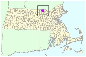
The Town of Townsend, MA is located in Middlesex County, in North Central Massachusetts, on the New Hampshire border
Townsend Memorial Hall
272 Main Street (Route 119)
Townsend, MA 01469
Town Hall is located in center of Townsend - 300 feet West of the intersection of Route 119 & Route 13, at red star below
- Directions to Town Hall (aka Memorial Hall) below
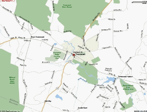
Click on map to enlarge
Directions To Memorial Hall
- From the East: From Route 495 in Littleton, MA, follow Route 119 West for 15 miles to the center of Townsend. Memorial Hall is on the left, just after the intersection of Route 13. Take the next left onto Jefts Street for parking in the rear.
- From the South: From Route I-190 North in Leominster, MA, merge onto Route 2 West for one exit, follow Route 13 North for 10 miles to the center of Townsend, take a left at the light onto Route 119 West. The Memorial Hall is on your left, take the next left onto Jefts Street for parking in the rear.
- From the West: From Route 2 in Leominster, MA, follow Route 13 North for 10 miles to the center of Townsend, take a left at the light onto Route 119 West. The Memorial Hall is on your left, take the next left onto Jefts Street for parking in the rear.
- From the North: From Route 101 in Milford, N.H., follow Route 13 South for 12 miles to the center of Townsend, take a right at the light onto Route 119 West. The Memorial Hall is on your left, take the next left onto Jefts Street for parking in the rear.